
- A Handbook of Thal Development Authority. (1954). Joharabad: Public Relation Division TDA. pp. 26-70.
- Abbas, M. W. (2015). The Role of TDA in the Progress of Thal with Special Reference to Bhakkar Region. Bahawalpur: Islamia University Bahawalpur. pp. 63-130.
- Abbas, M. W. (2020). Development and Settlement of the Thal Desert (1947-1969). Bahawalpur: Islamia University Bahawalpur. pp. 20-260.
- Mehar, A. H. (2003). Thal. Islamabad: Lok Virsa Publishing House. pp. 3-120.
- Bedi, T.D. (1934). Indebtedness in the Pastoral and Agricultural Zones of the Bhakkar Thal. Calcutta: Shadi Ram Monga Publishers. pp. 12-67.
- Census of Pakistan 1951. (1951). Karachi: Government of Pakistan. p. 3.
- Colony File. (1969). Bhakkar. Revenue Division Thal Development Authority. pp. 20-40.
- Gazetteer Layyah District 1984. (1984). Lahore: The Research and Gazetteer Cell Punjab. pp. 128-29.
- Sameer, I. & Ijaz, S. (2012). Colony Manual, Lahore: KLR Publisher. pp. 1170-1190.
- Interview Chaudhry Muhammad Maqsood Ahmed. (2017). Advocate Lahore High Court. Bhakkar.
- Khokhar, Malik Ghulam Shabir. (2002). Thal Development Authority and Galaxy of Revenue Tenures. Lahore: Kosar Brothers. pp. 56-80.
- Leel, Falak Sher. (2015). Sar-Zameen Bhakkar. Bhakkar: Prime Publishers. pp. 45-80.
- Leel, Falak Sher. (2019). Bhakkar Ki Saqafti Tareekh. Dera Ismail Khan: Sultan Printing Press. pp. 37-39.
- Qureshi, J.M. (1995). An Economical Survey of Eight Typical Villages of Thal. Lahore: Board of Economic Inquiry. p. 67.
- Statistics of TDA. (1969). TDA Record. Bhakkar: Housing Department. pp. 22-270.
- The Thal Development Act of 1949. (1949). Lahore: Punjab Government Printing Press. pp. 15-90.
- The West Pakistan Gazette. (1969). Lahore: Part 1. pp. 200-914.
- Thind, Mehar Noor Muhammad. (1994). Tareek Layyah. Layyah: Lok Punjab Publishers. pp. 10-165.
- Thind, Mehar Noor Muhammad. (2009). Tareek Bhakkar. Layyah: Lok Punjab Publishers. pp. 3-220.
- West Pakistan Year Book. (1962). Lahore: Information Department. pp. 12-27.
- West Pakistan Year Book. (1962). Lahore: Information Department. pp. 12-48.
- West Pakistan Year Book. (1963). Lahore: Information Department. pp. 10-34.
- West Pakistan Year Book. (1965). Lahore: Information Department. pp. 12-89.
- West Pakistan Year Book. (1968). Lahore: Information Department. pp. 08-23.
Abstrict
The British introduced canal colonies system in Punjab province and Thal Canal Colony is one of them. The work on Thal Canal Colony had started in 1939 and could not be completed till the partition of the Subcontinent. Newly established state of Pakistan planned to complete the Thal Canal Colony Project on the emergency basis not only to solve the refugee problem but also to settle the people whose lands were destroyed by river action or due to waterlogging and saline. The main objective of this research work is to study the whole settlement process of the Thal in detail. The historical research approach has been applied, and data has been collected through primary and secondary sources. The Government of Pakistan not only completed the settlement process successfully but also provided all modern facilities of life to the new settlers.
Keywords
Adjustment, Colonization, Refugees, Settlement, TDA, Thal, Thal Canal Colony.
Introduction
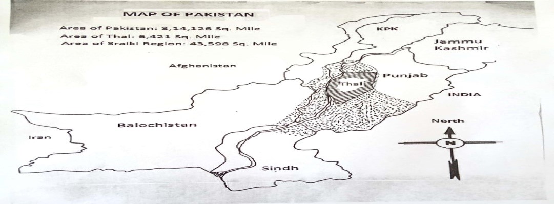
The desert of Thal lies along the left bank of the Indus River in Punjab Pakistan, having five million acres area (Mehar, 2003). The plan of Thal Canal Colony Project had prepared by the Punjab Government in 1873 but was delayed till 1939 by the British because they prioritized other projects such as Bhakra Dam Project, Sutlej Valley Project and Sukkar Barrage Project etc. At last, the central government accepted Thal Canal Colony Project and construction work began in the year of 1939. The construction of Jinnah Barrage at Mianwali and Main Line Upper was started but stopped due to Second World War in 1942. The construction work was resumed in the year of 1943, and the British government completed Jinnah Barrage and Main Line Upper till their departure from the Sub-continent in 1947 (West Pakistan Year Book 1962, 1962). At the time of partition, only 139 acres of the Thal desert was watered by Thal Canal. The newly established Government of Pakistan allotted land to tenants under different schemes, but hot climate conditions, huge dunes and other challenges blocked the development of the region. The new settlers left the Thal region one after another due to big challenges; they faced in the deserted land. The watercourses of Thal Canal were also chocked up by the sand due to frequent wind storms. In a nutshell, Thal Colony Project was failed badly. The nonstop pressure of refugees on upper Punjab and failure of Thal Canal Project put the provincial and central governments under tremendous pressure in the initial years of Pakistan. Both governments decided to resolve the problem once for all and created the Thal Development Authority (TDA hereafter) in 1949. TDA remained serviceable for the next twenty years from 1949 to 1969, chasing the goals of settlement and development in the Thal region (Thal Development Act of 1949, 1949). That desert is located across Muzaffargarh, Jhang, Layyah, Khushab, Bhakkar and Mianwali districts having an area of five million acres. TDA was responsible for the development and settlement of state and acquired land of Thal region inside and outside boundaries of Thal Canal. It was abolished by the government in 1969, but till then TDA had made marvelous achievements in settlement of the region, levelling of land, the extension of irrigation, and establishment of new villages (A Handbook of Thal Development Authority, 1954).
The Thal Desert in the Map of Pakistan
>
Literature Review
TDA act of 1949 is a basic source about TDA, its powers and duties, formation, working domain, accounts, finance, accounts and dissolution. A Handbook of Thal Development Authority published by public relation division of TDA provides in-depth information about the authority; its formation and first five year’s work and researcher have to consult other sources for remaining years of the authority. A book, “Thal Development Authority and Galaxy of Revenue Tenures” written by Malik Ghulam Shabir Khokhar provides valuable information about acquisition and adjustment of land carried out by TDA. This book is only about acquisition and adjustment and silent about the settlement of the region. J.M. Qureshi book, “An Economical Survey of Eight Typical Villages in the Thal” is a research work which provides valuable information about socio-economic conditions of the masses of the eight villages. T.D. Bedi also provided comprehensive information through his research work carried out before partition with the name, “Indebtedness in the Pastoral and Agricultural Zones of the Bhakkar Thal”. It described the socio-economic conditions and physical aspects of the masses of the region in detail. Gazetteers of District Muzaffargarh and Mianwali are very helpful for the provision of in-depth information about Thal desert, its history, physical aspects, and socio-economic condition of people. Colony Manual book published by KLR and written by Sharjil Ijaaz and Sameer Ijaaz is a comprehensive source about the colonization official notification of the whole Pakistan since the British age. But it only makes available the notification regarding colonization, not any information about the whole process of colonization. A book, “Takeekh Riasut Mankera” written by Malik Dost Muhammad Khokhar and published by Bhakkar Printing Press Bhakkar throws light on the history of Mankera state especially. A very important research work carried out by Mehr Abdul Haq with the name, “Thal” published by Lok Virssa Publishers Islamabad is the only source written in Urdu. It provides significant data regarding flora and fauna, natural division, history and culture of Thal desert in detail. The only book regarding the history of canal colonies is, “Punjab under Imperialism 1885-1947” written by Mr Imran Ali. It is a research work and provides in-depth knowledge about the whole process of canal colonization in the British era, but it is silent on Thal Canal Colony after partition. Suppose research wants to know history, socio-economic conditions of the people before the arrival of the British, the Land Revenue Settlement Report of D.I.Khan (1872-1879) prepared by George Tucker is the best option. Latest research work carried out by Mr Muhammad Wasim Abbas; Assistant Professor Pakistan Studies Government College Dullewala District Bhakkar is “Role of TDA in the Progress of Thal with Special Reference to Bhakkar Region”. It only provides valuable information about the settlement and development of Bhakkar region, not of the whole Thal desert. A researcher can get access to year wise information about the settlement and development of the Thal region by reading yearbooks published by Public Relation Department Lahore from 1950 to 1969. After in-depth and in detail reading of available literature, it is obvious that not even a single research has been carried out about the settlement of the Thal region. This specific study will provide comprehensive information about the Thal, TDA and its services. It will also throw light on acquisition, adjustment and allotment of the land to different segments of society from 1949 to 1969.
Acquisition and Adjustment of Land
Thal Canal was constructed to irrigate almost 2.1 million acres out of which 0.37 million acres was state land whereas 1.8 million acres was occupied by private landholders. TDA appointed land acquisition officers to acquire land from the locals in the areas of District Khushab, Mianwali, Bhakkar, Layyah and Kot Adu tehsil of District Muzaffargarh. Full powers were granted to acquisition officers through TDA Act of 1949 by the authority (Khokhar, 2002). Thal Development Authority classified land into three categories during the process of acquisition, adjustment of land within and outside irrigation boundaries of Thal canal, which are as under:
1. Rain irrigated land.
2. Well irrigated land.
3. Un-cultivated wasteland.
Sameer Ijaz and Sharjeel Ijaz (2012) describes that TDA acquired only uncultivated wasteland from local landholders within and outside irrigation boundaries. The authority did not acquire rain irrigated and well-cultivated land from the locals. The process of acquisition continued from local landholders till 1955. After the acquisition, the central government and local people, both were owners of the acquired land. The return process of land among local landholders according to the formula is known as adjustment of land. The Government of Punjab and West Pakistan had to issue different notifications for the return of acquired land to local landholders as they were deprived of their whole lands (West Pakistan Year Book 1963, 1963). The following notifications were issued by the provincial government time and again on successive demands of local landholders:
1. Notification No. 53-C, Dated 5/1/1952.
2. Notification No. 226-Th, Dated 29/1/1953.
3. Notification No. 713-54/1199-Th, Dated 1/5/1954.
4. Notification No. 5284-C, Dated 27/11/1954.
Notification No. 713-54/1199-Th, dated 1/5/1954 given above at number three is known as Marginal Adjustment Formula (Sameer Ijaz & Sharjeel Ijaz, 2012). The main features of the formula are given as under:
1. TDA would acquire only un-cultivated and wasteland of Thal region. After the acquisition, the land would become government property.
2. According to the formula, the cultivated land would be land which was not shown either as un-cultured wasteland or which has remained fallow for at least eight successive harvests or not shown in harvest inspection register or a piece of land which cannot cultivate for 1951 summer crops.
3. TDA would not acquire land irrigated through well water.
4. TDA would not acquire any land from the landholder having land less than fifteen acres.
5. TDA would acquire 50 per cent land from the people having land less than a hundred acres but more than fifteen acres.
6. TDA would acquire 75 per cent land from the landholders having land more than one hundred acres.
7. Sixty-five rupees per acre would be charged as a development fee from the settler (Colony File, 1969).
The local landowners were not happy with marginal adjustment formula; therefore, the government issued another formula known as Slab Adjustment Formula. The locals were satisfied with Slab Adjustment Formula, but TDA strictly followed Marginal Adjustment Formula and later Supreme Court of Pakistan declared it a governing law (Abbas, 2015). The following table shows acquisition, adjustment of land and land available for development to the authority.
Table 1. Land Available for Development to TDA
| S. No width="397">Detail About Acquisition and Adjustment of Land width="85">Area in Acres | > 1 width="397">Thal desert area width="85">50,00,000 | > 2 width="397">The area under Thal Project Canals width="85">21,55,733 | > 3 width="397">State land in Thal Project Canals width="85">4,06,555 | > 4 width="397">The land occupied by indigenous land proprietors width="85">18,24,733 | > 5 width="397">land acquired by TDA from indigenous land proprietors width="85">9,38,778 | > 6 width="397">Land adjustment (Returned to local landowners) width="85">4,07,297 | > 7 width="397">Outstanding acquired land available for settlement width="85">5,31,481 | > 8 width="397">The total area available to TDA for Development within the irrigation boundary width="85">9,06,036 | > 9 width="397">Total state land available to TDA for development outside the irrigation boundary. width="85">7.15000 |
Source: West Pakistan Year Book 1965, P. 41.
Settlement Schemes of TDA
TDA allotted state and acquired land to new settlers under various colonization schemes. The beneficiaries were not only the refugees but also people whose land had been damaged by waterlogging and saline or by river action. Some colonization schemes allowed ordinary people from all around the country to buy the land. The authority first reserved land for forests, roads, and new villages then planned to allot the remaining land under different settlement schemes (Gazetteer Layyah District 1984, 1984). The details of different colonization schemes announced by the authority from 1949 to 1969 for refugees as well as for locals inside and outside the irrigation boundaries of Thal Canal are given below:
Tube well Scheme 1952
Thal Development Authority introduced Tube Well Scheme 1952 vides Notification 1486-C, Dated October 31, 1952, on the recommendation of Punjab Government to settle the migrants, locals and other people from the country. Each lot consisted of one hundred and fifty acres located outside the irrigation boundary. It is important to mention that this scheme was introduced only in Bhakkar region. The lots were allotted in Rakh Dhinghana, Rakh Khasoor, Rakh Haiderabad, Rakh Haitu and Rakh Jandanwala. TDA cancelled a few lots due to incompletion of already given terms and conditions in the notification (West Pakistan Year Book 1961, 1961). Main terms and conditions of the Tube Well Scheme 1952 are given below:
1. The allottees had to pay one hundred rupees as an advance to TDA for trail boring; if boring would successful, the advance amount would be returned.
2. If trail boring failed, the allottees had to pay one hundred rupees more as an advance to the authority for another boring.
3. If the second boring failed, the said lot would be declared unfit for allotment.
4. After successful boring, the allottees would credit nine rupees per acre to the authority, and the land would be awarded on lease.
5. After successful allotment, the tenant needed to shift his residence to his lot in the first six months, and he would construct his house in the first eighteen months.
6. There was an option that the tenant would deposit the price of land in a lump sum or eighty easy equal instalments.
7. If the tenant failed to pay an instalment on time, he would deposit 2.50 per cent an additional amount as an interest to the authority.
8. The land rights of a plot reserved for residence at a village site would be awarded after successful completion of terms and conditions (Statistics File of TDA, 1969).
Table 2. Tube Well Scheme 1952 Allotted Lots Statement
| S. No width="11%">Name of District width="14%">Total No. of lots Allotted width="16%">The area Allotted in Acres width="16%">No. of lots of Property Rights Granted width="13%">No. of Resumed Lots width="16%">No. of Lots Under Process | > 1 width="11%">Khushab width="14%">- width="16%">- width="16%">- width="13%">- width="16%">- | > 2 width="11%">Mianwali width="14%">- width="16%">- width="16%">- width="13%">- width="16%">- | > 3 width="11%">Bhakkar width="14%">1036 width="16%">155400 width="16%">471 width="13%">282 width="16%">283 | > 4 width="11%">Layyah width="14%">- width="16%">- width="16%">- width="13%">- width="16%">- | > 5 width="11%">Kot Adu width="14%">- width="16%">- width="16%">- width="13%">- width="16%">- |
| S. No. width="14%">Name of the District width="10%">No. of Allottees width="15%">Total Land in Acres width="15%">Total No. of Allotted Lots width="16%">Total No. of Cancelled Lots width="17%">No. of lots Under Process | > 1 width="14%">Khushab width="10%">- width="15%">- width="15%">- width="16%">- width="17%">- | > 2 width="14%">Mianwali width="10%">- width="15%">- width="15%">- width="16%">- width="17%">- | > 3 width="14%">Bhakkar width="10%">759 width="15%">18975 width="15%">198 width="16%">122 width="17%">439 | > 4 width="14%">Layyah width="10%">- width="15%">- width="15%">- width="16%">- width="17%">- | > 5 width="14%">Kot Adu width="10%">- width="15%">- width="15%">- width="16%">- width="17%">- |
| S. No. width="98">Name of Scheme width="66">Total No. of Lots width="77">State Land in Acres width="75">TDA Land in Acres width="82">Total Land in Acres width="87">Area | > 1 width="98">Sheep breeding scheme width="66">211 width="77">2450 width="75">715 width="82">3165 width="87">In whole Thal |
| S. No. width="13%">Name of the District width="11%">No. of Allottees width="13%">Total Land in Acres width="15%">Total No. of Allotted Lots width="16%">Total No. of Cancelled Lots width="19%">No. of lots Under Process | > 1 width="13%">Khushab width="11%">125 width="13%">3536 width="15%">117 width="16%">- width="19%">08 | > 2 width="13%">Mianwali width="11%">35 width="13%">848 width="15%">32 width="16%">- width="19%">03 | > 3 width="13%">Bhakkar width="11%">1342 width="13%">31325 width="15%">1245 width="16%">- width="19%">97 | > 4 width="13%">Layyah width="11%">3005 width="13%">53663 width="15%">2120 width="16%">- width="19%">885 | > 5 width="13%">Kot Adu width="11%">- width="13%">- width="15%">- width="16%">- width="19%">- |
| S. No. width="14%">Name of the District width="11%">No. of Allottees width="13%">Total Land in Acres width="15%">Total No. of Allotted Lots width="18%">Total No. of Cancelled Lots width="17%">No. of lots Under Process | > 1 width="14%">Khushab width="11%">4602 width="13%">69083 width="15%">4582 width="18%">- width="17%">20 | > 2 width="14%">Mianwali width="11%">2930 width="13%">43950 width="15%">2845 width="18%">- width="17%">85 | > 3 width="14%">Bhakkar width="11%">4523 width="13%">67861 width="15%">4336 width="18%">- width="17%">187 | > 4 width="14%">Layyah width="11%">6614 width="13%">99210 width="15%">6283 width="18%">- width="17%">331 | > 5 width="14%">Kot Adu width="11%">1376 width="13%">20640 width="15%">1216 width="18%">- width="17%">160 |
| S. No. width="13%">Name of the District width="10%">No. of Allottees width="15%">Total Land in Acres width="15%">Total No. of Allotted Lots width="17%">Total No. of Cancelled Lots width="17%">No. of lots Under Process | > 1 width="13%">Khushab width="10%">- width="15%">- width="15%">- width="17%">- width="17%">- | > 2 width="13%">Mianwali width="10%">- width="15%">- width="15%">- width="17%">- width="17%">- | > 3 width="13%">Bhakkar width="10%">- width="15%">- width="15%">- width="17%">- width="17%">- | > 4 width="13%">Layyah width="10%">1585 width="15%">40043 width="15%">926 width="17%">- width="17%">659 | > 5 width="13%">Kot Adu width="10%">2351 width="15%">45475 width="15%">1446 width="17%">- width="17%">905 |
| S. No. width="162">Number of lots width="173">Land in acres width="142" valign="top">Area | > 01 width="162">150 width="173">7500 width="142" valign="top">In whole Thal |
Source: TDA Record File, Housing Department, Bhakkar. P. 38.
Tube Well Scheme 1963
TDA allotted 247 lots under Tube Well Scheme 1963 vide Notification No. 629-63/711-CII, Dated February 15, 1963, on behalf of Punjab Government. This scheme was introduced again in the history of Thal Canal Colony because vacant and cancelled lots land of Tube Well Scheme 1952 was available. The terms and conditions of both tubes well schemes were different. The period of lease for this scheme was twenty years (Abbas, 2020). Following are the terms and conditions of the scheme:
1. A lot of one hundred acres was awarded to every tenant.
2. The tenant would submit his application along with a fifty rupees court fee stamp.
3. The tenant would pay an amount as security in advance.
4. Amount of security would be refundable to the tenant when the agreement was ended.
5. The allottees would use their land only for agriculture purpose.
6. On the desire of tenant, the time of allotment would be prolonged from ten years to twenty years.
7. The allottees would be responsible for installing a tube well of his own within two years of his allotment, and he would also keep it operational during his who tenancy period.
8. The rate of tenancy would be six rupees per acre for the first ten years, whereas it would be nine rupees per acre for the next ten years.
9. The allottees had an option to pay the amount of land in instalments or lump sum.
10. The tenant would be responsible for bringing half of his lot into use within five years of his tenancy.
11. The tenant would plant at least one tree per acre.
12. When the property rights of the lot would be handed over to the tenant, the land rights of the residential plot would also be handed over to him (Colony File, 1969)
Table 9.
Tube Well Scheme 1963 Allotted Lots Statement
| S. No. width="14%">Name of the area width="10%">No. of allottees width="15%">Total land in acres width="15%">Total No. of allotted lots width="16%">Total No. of cancelled lots width="17%">No. of lots under process | > 1 width="14%">Khushab width="10%">- width="15%">- width="15%">- width="16%">- width="17%">- | > 2 width="14%">Mianwali width="10%">- width="15%">- width="15%">- width="16%">- width="17%">- | > 3 width="14%">Bhakkar width="10%">195 width="15%">31849 width="15%">148 width="16%">31 width="17%">16 | > 4 width="14%">Layyah width="10%">52 width="15%">7658 width="15%">42 width="16%">- width="17%">10 | > 5 width="14%">Kot Adu width="10%">- width="15%">- width="15%">- width="16%">- width="17%">- |
Source: Colony File, Revenue Department Khushab, P. 20. Colony File, Revenue Department Mianwali, P. 28. Colony File, Revenue Department Bhakkar, P. 33. Colony File, Revenue Department Layyah, P. 26. Colony File, Revenue Department Muzaffargarh. P. 37.
Free Grants of TDA Land
TDA allotted 14941 acres state land to Moeens and Lamberdars as a free grant for two decades temporarily. It is very important to clear that Moeens were skilled persons of the society such as cobbler, carpenter, blacksmith and potter etc. whereas Lamberdar was a very important figure of a village because he was responsible for the collection of revenue from the landowners (Statistics File of TDA, 1969).
Table10. Free Grants of TDA Land
| S. No. width="97">Name of Grant width="101">State Land in Acres width="96">TDA Land in Acres width="102">Total Land in Acres width="87">Area | > 1 width="97">Moeens grants width="101">5879 width="96">2978 width="102">8857 width="87">In whole Thal | > 2 width="97">Grand Total width="101">9809 width="96">5132 width="102">14941 width="87">In whole Thal |
Source: TDA Record File, Housing Department, Bhakkar. P. 40.
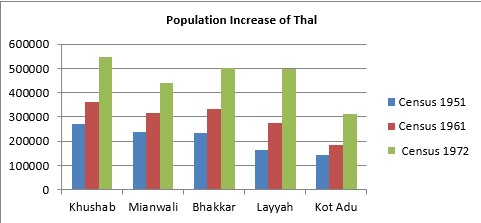
The process of settlement had continued for twenty years in TDA era. Census reports of District Muzaffargarh, Mianwali and Sargodha, show a big increase in the population of Layyah and Kot Adu region whereas to a large extent in the population of Khushab, Mianwali and Bhakkar regions. The following graph shows the population increase in Khushab, Mianwali, Bhakkar, Layyah and Kot Adu regions during twenty years of TDA:
Source: Colony File, Revenue Department Khushab, P. 97. Colony File, Revenue Department Mianwali, P. 89. Colony File, Revenue Department Bhakkar, P. 70. Colony File, Revenue Department Layyah, P. 45. Colony File, Revenue Department Muzaffargarh. P. 76.
TDA not only settled the people but also provided all basic facilities of life such as health, education, electricity, roads etc. TDA loaned amount to the farmers for the purchase of seeds, equipment and to build their houses in villages. Agricultural experts provided training to the new settlers so that they could be able to survive in the new atmosphere of Thal desert. The authority set up two main livestock farms for the delivery of meat and low-priced labor for farming. Besides, eight dispensaries for animals were also established to treat diseased animals. Main cities of Thal were connected to all newly established towns and villages through link roads. The authority established Mandi Towns, textile mills, sugar mills and woolen mills for the sale of agricultural products. In a nutshell, TDA ensured a balanced and equal development of the area just in twenty years of its working.
Conclusion
The desert of Thal was famous from centuries for wastelands, harsh weather, wind storms and scarcity of rainfall. The British introduced Thal Canal Colony in 1939, but the project could not be completed due to the Second World War and partition of Subcontinent. Keeping in view the weather conditions and land characteristics of desert, the Government of Pakistan initiated the settlement process of Thal for the settlement of refugees and the people whose lands were destroyed due to waterlogging, saline and river action. TDA completed settlement process successfully in twenty years from 1949 to 1969. All basic and modern facilities of life were also provided to the new settlers of the area for permanent and equal development. The people of Thal are happy and full of confidence in their future.
References
Cite this article
-
APA : Abbas, M. W., Ahmad, M. S., & Ahmad, I. (2020). Settlement of the Thal Desert (1949-1969). Global Political Review, V(II), 34-45. https://doi.org/10.31703/gpr.2020(V-II).04
-
CHICAGO : Abbas, Muhammad Wasim, Mian Saeed Ahmad, and Imran Ahmad. 2020. "Settlement of the Thal Desert (1949-1969)." Global Political Review, V (II): 34-45 doi: 10.31703/gpr.2020(V-II).04
-
HARVARD : ABBAS, M. W., AHMAD, M. S. & AHMAD, I. 2020. Settlement of the Thal Desert (1949-1969). Global Political Review, V, 34-45.
-
MHRA : Abbas, Muhammad Wasim, Mian Saeed Ahmad, and Imran Ahmad. 2020. "Settlement of the Thal Desert (1949-1969)." Global Political Review, V: 34-45
-
MLA : Abbas, Muhammad Wasim, Mian Saeed Ahmad, and Imran Ahmad. "Settlement of the Thal Desert (1949-1969)." Global Political Review, V.II (2020): 34-45 Print.
-
OXFORD : Abbas, Muhammad Wasim, Ahmad, Mian Saeed, and Ahmad, Imran (2020), "Settlement of the Thal Desert (1949-1969)", Global Political Review, V (II), 34-45
-
TURABIAN : Abbas, Muhammad Wasim, Mian Saeed Ahmad, and Imran Ahmad. "Settlement of the Thal Desert (1949-1969)." Global Political Review V, no. II (2020): 34-45. https://doi.org/10.31703/gpr.2020(V-II).04